Station Map/zh-hant: Difference between revisions
Appearance
Created page with "與{{pll|Route Map|鐵路配線圖}}相似,若您擁有{{pll|Dispatcher|「調度員」執照}},能透過以通訊無線電瞄準圖面的{{pll|Switches & Switch Signs|轉轍器}}圖示,遙控切換它們。" |
No edit summary |
||
| Line 6: | Line 6: | ||
</div> | </div> | ||
與{{pll|Route Map|鐵路配線圖}}相似,若您擁有{{pll|Dispatcher|「調度員」執照}},能透過 | 與{{pll|Route Map|鐵路配線圖}}相似,若您擁有{{pll|Dispatcher|「調度員」執照}},能透過瞄準圖面的{{pll|Switches & Switch Signs|轉轍器}}圖示,遙控切換它們。 | ||
<div lang="en" dir="ltr" class="mw-content-ltr"> | <div lang="en" dir="ltr" class="mw-content-ltr"> | ||
Revision as of 13:34, 15 April 2025
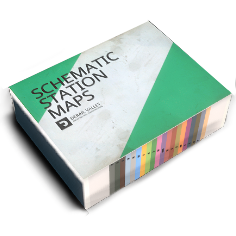
車站配線圖是一書本物品。和旨在顯示具體鐵路網和車站位置的世界地圖不同,車站配線圖中以示意圖形式繪有個別站場、車場的軌道佈局。
It is used for navigation and identification of tracks, switches, service points, station offices, shops and other features within a station. To help identify these features, there’s a legend view on the first page.
與鐵路配線圖相似,若您擁有「調度員」執照,能透過瞄準圖面的轉轍器圖示,遙控切換它們。
Each yard layout shows world directions and orientation to the nearest station office, which can help navigate in combination with a compass.
頁面底部附有寫著車站簡稱的頁籤,能夠點選它們快速翻頁。
